Biking around the eleven Finger Lakes in New York
- Erin Hassett

- Aug 16, 2022
- 9 min read

In Upstate New York, there are eleven long bodies of water that form aqueous fingers. I like to think of them as the Earth's stretch marks, but, naturally, it was the glaciers that scraped their way down the state, leaving behind the beautiful lakes that have become tourist destinations: the 500+ miles of the Finger Lakes Trail runs across the state near these lakes, you can participate in extensive wine tours in this area as well as swim, boat, wind surf, etc., and, of course, you can bike around all of them!
Living in this region and being a cyclist, I naturally needed to take on the challenge. Plus, it was a good excuse to explore the area and get to know the place I lived. A useful resource for biking around the Finger Lakes is the "Bike the Finger Lakes 11 Challenge" website, hosted by the Finger Lakes Cycling Club (FLCC), which has route map suggestions and notes on parking and services. I only discovered this website when I was 6/11 completed, but it is very useful. Below, I detail my experience biking around the lakes, and I share the elevation profile and maps of my routes. Enjoy!
Read the story of each of the Finger Lakes here.
Writing, generally, in the order of completion:
Cayuga Lake
I have biked around Cayuga a number of times now, and we typically always bike clockwise to get the busy highway section with little shoulder done first thing in the morning while there are fewer cars. The route is completely paved and about 90 miles, just shy of 100, so we typically add an extension to get the one hundo. On MapMyRide, there is a no-extension, wrap-around route that clocks in at 87 miles and 3,304 ft of elevation gain, and on the FLCC website, it's a larger loop that's 97 miles and 3,261 ft of gain (but it's on fewer state highways). So, there are plenty of ways to get around the lake, depending on your elevation and length preference. One of our longest rides was 125 miles around the lake that also required an extension at the end to retrieve a water bottle, and this route was 5,465 ft of gain, taking us 9hr 11 mins. Ultimately, we ended back in Ithaca at mile 100 in the elevation profile below.
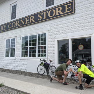
To the south of the lake is my beloved Ithaca which sits in a valley (that you have to climb out of), and to the north is Montezuma with a convenient Circle K gas station. Around the entire lake you can find many wineries and farm fields. The small yet punchy ups and downs warm up your leg muscles on the way to Montezuma, and before you realize it, you are halfway done. The second half is definitely slower and harder, but it makes post-ride ice cream and/or beer definitely worth it. We didn't have any issues refilling at gas stations or stores; you pass through plenty of small towns along the way. A particular great stop is Sauder's Store on the west side of the lake close to Montezuma, a fabulous country café with homemade foods and snacks. We also stop at King Ferry Corner Store halfway down the east side of the lake.

Seneca Lake
Like Cayuga, we have biked around Seneca Lake a number of times, and we always go counterclockwise! This ride is all paved, 80 miles long, and has 2,977 ft of gain, and it took us 6hr 10 mins to complete. Our ride on Strava is here. The FLCC website has the route going clockwise (which I disagree with), giving you a big climb at the very beginning, but this is avoided if you go counterclockwise: heading counterclockwise, you quickly take an access road, giving you a more manageable, stepwise approach to the elevation gain. Furthermore, you have a huge, exhilarating descent into Watkins Glen which you would otherwise have to climb if you rode clockwise.
Watkins Glen sits at the south of the lake, and Geneva is in the north. Both towns are super cute and worth exploring/ taking a rest break. We always finish conveniently at Ben and Jerry's in Watkins Glen, and it's also worth taking a dip in Seneca Lake and exploring the gorges/falls nearby at the State Park. Check out Scuteri's Cannoli Collection, too!

Skaneateles Lake
We biked clockwise, and it was approximately 36 miles around and took 3hr 22 mins to complete. Our route can be found here. While this is a fairly short ride, it is certainly one of the hardest, with an elevation gain of over 2,600 ft! Another downloadable route option can be found here on Komoot, clocking the ride in at 40 miles, 2,350 ft of gain, and 3 hours to complete. The FLCC website also has the route going clockwise, but they mapped out 40.2 miles and 2,314 ft of climbing. The route was mostly all paved, but there were some sections of loose, crushed gravel that could make road tires slip a little bit, especially on downhills.
The ride itself was beautiful, with farm fields and lakeside views that are characteristic of the region. Skaneateles is such a cute town with touristy shops, bakeries, restaurants, and a beautiful view. It is worth going to the town for a day just to explore and window shop.
This ride also marked the final finger lake for Carrie! We celebrated by going to The Elephant and the Dove, a hip and modern Mexican restaurant that served large portions, enough for some hungry bikers.

Keuka Lake
This is one of the prettiest lake rides, characteristic of its "Y" shape, and it's very easy (note the elevation profile). The ride itself is around 60 miles when you dip into "Y" (my Strava stopped a few miles short), and it took roughly 3 hr 40 mins to complete with 1,833 ft of gain going clockwise. Otherwise, you can avoid the inner part of the "Y", and the route can be 44.9 miles and 1,569 ft of gain, according to the FLCC website. The site says that it avoids a "wickedly steep climb", but, compared to other climbs around the other Finger Lakes, this "climb" was barely noticeable. Personally, it was so beautiful following the lake the whole time, that I would do it this way again.
Hammondsport is south of the lake and is very tiny compared to Penn Yan in the north. Both places have gas stations and restaurants to fill up on water and food. As you can tell, this is one of the flattest routes around the Finger Lakes; you can go very quick and enjoy all the little rollers and slight, quad-engaging uphills. When we rode, a section of the road was under construction, so we had to ford the steep ditch, but this may be fixed now. A small, off-road section was a ton of fun to ride, and then we zoomed our way along the paved rolling hills by the lakeside houses. 10/10

Owasco
We completed Owasco lake for 5/11! Our ride on Strava can be found here. Circling the lake was a length of 31.8 miles,1,388 ft of elevation gain, and it took us 2hr 28 mins. We parked at the south end and rode counterclockwise, and the ride was all paved. The FLCC website route is 37 miles and 1,641 ft of climbing going clockwise.
At the north end of the lake is a beautiful park that is perfect for lunch and ice cream (at Seb's). On the east side of Owasco, the road was a little further from the lake, but you could catch a glimpse of the lake across the farm fields. On the west side, you ride closer to the water alongside lake-front properties. The rolling hills were definitely manageable, and the frequent downhills were a lot of fun! All of the roads were perfectly paved.

Otisco
For 6/11, we completed the 16.6 miles around Otisco Lake: Strava map here. We parked at the north end next to a park and rode clockwise. It took us 1hr 34 mins and 1,224 ft of elevation gain. You can see from the elevation profile that around 6 miles there is a mega incline, on Moon Hill Rd, and the grade at its steepest ranges from 14-19%. I had to stop and walk a few times, but Uri powered through to the top. If I were to do this again, I might opt to go counterclockwise because I would prefer the gradual climb over the insane intensity of Moon Hill, though maybe another route could avoid this completely. After Moon Hill, it was easy coasting and slow rolling downhills. We rode this the same day we biked around Owasco, so I was pretty exhausted and grumpy for this ride.
The FLCC website also has the route going clockwise and maps the ride at 46 miles, instead of 16.6, and 1,787 ft of gain. The major difference in lengths is because this route starts in Homer instead of directly on the side of Otisco Lake.

Canandaigua
We started this route going counterclockwise, and our Strava map is here. The route was all paved, 42 miles long, and took 3 hr 20 mins to complete with 2,208 total ft elevation gain. It seemed like a lot of elevation for 40 miles, but it all felt concentrated in a few isolated hills. Bopple Hill was not easy: from mile 12.7 to 14.4 and boasting a 13-17% grade in some of the steepest sections, we slowly cranked away at this incline. This was my second lake (the other being Otisco) where I had to stop, dismount, and walk for a portion, but I found out (afterwards) that there is a route to avoid Bopple Hill entirely. The warm-up hill before Bopple was a quad burner, and there was a mild hill around mile 30 that was noticeable but not too bad, other hills considered. The FLCC website has a route that is 45 miles and 2,171 ft of gain going counterclockwise.
On the north side of the lake is the town Canandaigua. We arrived on a Saturday and was pleasantly surprised to find ourselves at the lively, outdoor farmer's market. There were booths displaying arts and crafts and food all down Main Street, and live music was being played in the main square. This was a beautiful and rewarding ride; one of my favorites, even considering the difficulty.

Conesus
One of the flattest rides you will do around the Finger Lakes is Conesus. It was both very easy and a lot of fun: Strava map here. It was all paved,18.4 miles around, and 338 ft of gain, taking me 1 hr 14 min to complete. I started at a public park which had a gas station across the street for any last minute snacks/water. Finishing at the park was lovely because there were great places to picnic and relax after riding. The route from the FLCC website is a 19.6 mile ride with 673 ft of climbing. Overall, this was very easy to knock-out with a few of the other smaller lakes in the area, namely Hemlock and Canadice.

Hemlock
After riding around Conesus, it was a 12 min drive to get to the top of Hemlock at a small parking pull out (the Strava map is here). The ride was completely paved, 24.9 miles long, and took 2 hr 7 mins to complete with 1,627 ft gain. This was definitely a leg workout compared to Conesus with the multiple long climbs. The route itself is not very close to the lake for a large portion of the ride, so you only get good views at the starting/end points. There aren't any services, and a part of the road was under construction close to the end (7/20/22), but you could still walk through it. This wasn't my favorite ride; it felt like a lake to just check off.

Canadice
Canadice was such a cute lake to bike around (Strava map here). It was 7.9 miles long, and I completed it in 40 mins with only 108 ft elevation gain. From the top of Hemlock to the top of Canadice was a 6 min drive, and there is a large, gravel parking area available. Half of the lake was a quiet and sleepy paved road, without a shoulder, and the other half was bumpy gravel (so maybe don't use a road bike with skinny tires). It doesn't really matter if you go clockwise or counterclockwise because it is so short and flat, and there are no other direct routes around. There are also no water stops or services along the route.
I paired Canadice with Hemlock and Conesus for three lakes completed in one day because it's really too short to do on its own.

Honeoye Lake
The last Finger Lake! I rode clockwise, and it was 18.1 miles, 446 ft of gain, and took 1 hr and 5 mins to complete: Strava map here. I parked off-street in front of some businesses, but Sandy Bottom Park is also nearby. There were plenty of places to get water and food in the town of Honeoye, but, to my dismay, the Cornerstone Market was closed. I really want to go back when they are open!
The ride was fast and relatively flat, with just a whisper of rolling hills. While there wasn't much of a shoulder, the roads were quiet and not heavily trafficked. Some loose gravel on the lower east side of the lake was worth being cautious about, but otherwise the pavement was good. It was such an enjoyable little ride to get the legs moving, even if it wasn't physically challenging.

Now onto the next challenge! What shall it be?
Happy tailwinds!



















Comments